


The Shoreland Water Quality Protection Act was originally named the Comprehensive Shoreland Protection Act (CSPA) and was enacted into law in the 1991 session of the legislature. The act establishes minimum standards for the subdivision, use and development of shorelands adjacent to the state's public water bodies. On July 1, 2005, Senate Bill 83 established a commission to study the effectiveness of the Comprehensive Shoreland Protection Act. On July 1, 2008, broad changes were made and included limits on impervious surfaces, provisions for buffers in which vegetation removal was limited, shoreland protection along rivers designated under RSA 483 (Designated Rivers), and the establishment of a permit requirement for new construction, excavation and filling activities within the protected shoreland. During the 2011 legislative session, the CSPA was renamed to the Shoreland Water Quality Protection Act and included changes to vegetation requirements within the natural woodland and waterfront buffers, the impervious surface limitations and included a new shoreland permit by notification process.
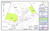
In keeping with recent changes to legislation, we undertake many of these shoreland application projects in our area. This approved plan is an example of a Geometres Blue Hills Shoreland Impact Plan. It has been revised to reflect the as built conditions of the lot, as well as the restoration of a disturbed area within the waterfront buffer that was not permitted by NHDES.


Géomètres Blue Hills, LLC
Copyright 2013 Geometres Blue Hills, LLC - 240 Hornetown Road, Farmington, NH 03835