


Géomètres Blue Hills, LLC
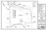
Geometres Blue Hills was contracted to survey the boundaries of this fairly large parcel. The
site included some challenging terrain; being located on one side of Blue job Mountain, and
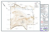
containing a large portion of Oxbow Pond. The topography was done in conjunction with
Eastern Topographics. Geometres Blue Hills used modern GPS surveying equipment to set
control points and aerial targets across the property in preparation for their flight. In addition
we used conventional means to fill in any areas in the topography that were to densely
forested for accurate measurements from the air.
Sheet 1,
(Boundary)
(Boundary)
Sheet 2,
(Boundary with Topography)
(Boundary with Topography)
Copyright 2013 Geometres Blue Hills, LLC - 240 Hornetown Road, Farmington, NH 03835